|
|
|
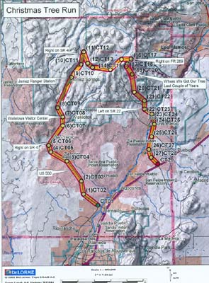
The Christmas Tree Run isn’t really a trail; it’s the route we take each year to cut down our Christmas Trees. There are several areas where you can cut trees, both in the Santa Fe and Cibola National Forests. Regardless of where you go, however, you must obtain a permit prior to cutting down a tree, (from the appropriate Ranger District). We normally go to Area B in the Santa Fe National Forest. For all area of the Santa Fe National Forest, permits (which are $10) are available at the Jemez Ranger Station in Jemez Springs (weekdays only), and also at the Walatowa Visitors Center just north of the Jemez Pueblo (both weekdays and weekends). We normally meet at 9 am at the Conoco Station on SR 528 at US 550, travel northwest on US 550, then north on SR 4. Area B is a few mile stretch after turning onto FR 289. Once finished, you can continue south on FR 289, then left on SR 22, through Cochiti, and back to I-25. The route consists mostly of paved roads, until the turn off onto FR 289, which is a dirt road. There are a few "bumpy" areas towards the end of FR 289, but the road becomes paved again once you hit SR 22. The route is about 90 miles long and takes approximately 5 to 6 hours or so to complete (including stops for your tree permit, tree cutting, and lunch). Difficulty Rating: One (1) Easy
Notice: Off-highway travel is by its very nature potentially dangerous and could result in property damage, injury, or even death. If you drive any of the trails on this web site, you acknowledge these risks and assume full responsibility. You are the final judge as to whether a trail is safe to drive, whether your vehicle is capable of the journey, and whether your skills are up to the challenge. The publisher of this web site disclaims any and all liability for property damage, bodily injury, or death that could occur to you or any of your passengers. To the best of my knowledge, the information contained on this page was accurate as of the time I road this trail during the Winter of 2001/2002. However, things change over time. And portions of this trail may no longer be legally accessible to motorized vehicles. Therefore, please be good stewards of our sport--always stay on designated trails . . . and always, always remember to Tread Lightly! Back to the New Mexico Trails Page
|
|
|