|
|
|
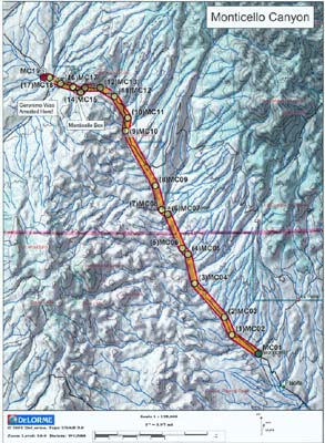
The Monticello Canyon Trail is just northwest of the small town of Monticello, which is approximately 21 miles northwest of Truth or Consequences. The trailhead is located a the intersection of SR 142 and FR 139. Ranging in elevation from approximately 5,200 feet to a little over 6,200 feet, the trail follows the Alamosa River/Creek from the town of Monticello upstream to the Monticello Box. There's private property on both sides of the canyon at several locations, so please stay on the main road. While in the canyon, you will cross the Alamosa River/Creek nearly 100 times. However, none of the crossings are more than about 12 inches, and many are less shallow. At Waypoint MC16 is the Monticello Box, which means the canyon sort of dead ends, boxing you in on 3 sides. However, it's a "mild" box with a very easy climb out of the back end. A little over a half-mile after the Monticello Box (at Waypoint MC17), there's a path off to the left, which leads to the remains of the Ojo Caliente Indian Reservation. You can park just to the right of the main road and explore this historic area where Indian Agent John Philip Clum arrested Geronimo and his band of renegade Apaches over 125 years ago, in April 1874. The Monticello Canyon Trail is about 17 miles long and takes only a few hours to reach the end, at the intersection of SR 52. To get back to the civilization, turn left (south) on SR 52 and follow it through the town of Winston, then southeast through Cuchillo, and back towards I-25. Most of SR 52 is paved, so you will want to air back up not long after exiting the trail. From the end of the trail, it will take you another hour or so to get back to the Interstate. Difficulty Rating: One (1) Easy
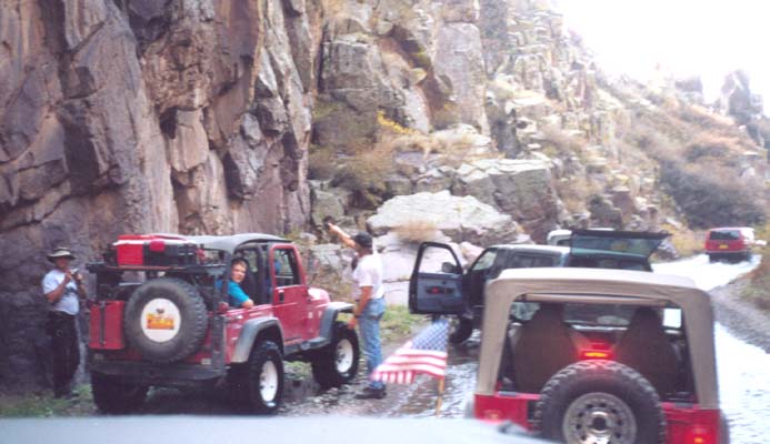
Click HERE for a FULL-SIZE printable map Here are a couple pictures from the Monticello Canyon
Trail. On the left,
Notice: Off-highway travel is by its very nature potentially dangerous and could result in property damage, injury, or even death. If you drive any of the trails on this web site, you acknowledge these risks and assume full responsibility. You are the final judge as to whether a trail is safe to drive, whether your vehicle is capable of the journey, and whether your skills are up to the challenge. The publisher of this web site disclaims any and all liability for property damage, bodily injury, or death that could occur to you or any of your passengers. To the best of my knowledge, the information contained on this page was accurate as of the time I road this trail during the Fall of 2002. However, things change over time. And portions of this trail may no longer be legally accessible to motorized vehicles. Therefore, please be good stewards of our sport--always stay on designated trails . . . and always, always remember to Tread Lightly! Back to the New Mexico Trails Page
|
|
|