|
The Tabasco Twister Trail is located in the Chile
Canyons area just North of Picacho Peak, about 5 miles west of Las Cruces.
To get to the trailhead, take I-10 West out of Las Cruces and take the Airport
Exit (# 132). Continue traveling west on the frontage road for approximately 4
miles. Turn right onto the paved road with the arched sign above that says "Carralitos
Ranch”. Ranging in elevation from approximately 4,200 feet to 4,700 feet, the
trail offers a great view of the Mesilla Valley and various surrounding mountain
ranges. This trail contains really big rocks and boulders, and really tall and
steep waterfalls. Two of the most difficult waterfalls have winch points. The
trail is a little over 14 miles long and takes a good 8 hours to complete.
Difficulty Rating: Four (4) Extreme
(based on my personal rating scale on the
Trails Page)
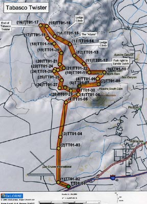
Click
HERE for a FULL-SIZE printable map
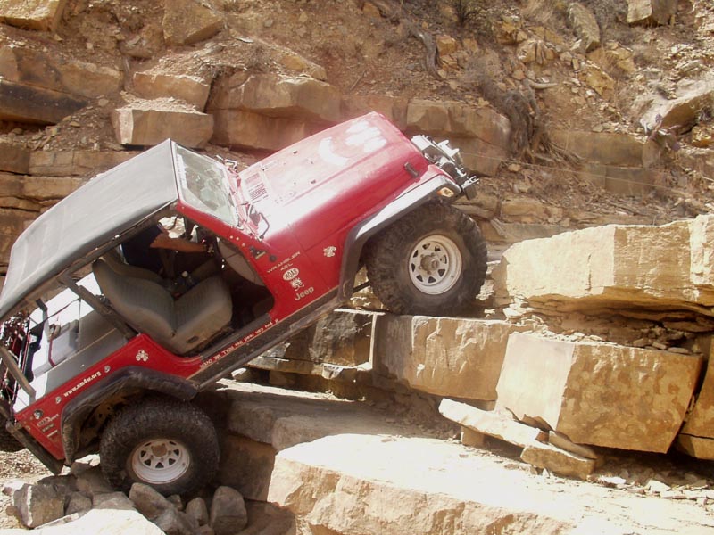
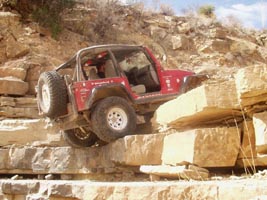
Here are a few pictures of "The Abyss" from the Tabasco
Twister Trail.
(note the winch cable in the first picture!)
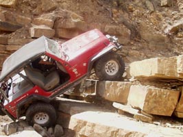
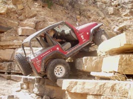
Click on picture for larger view, then "back" on
your browser to return here.
|
Waypoint: |
To: |
Distance |
Cumm. Dist. |
Bearing |
Lat |
Long |
|
TT01-01 |
|
|
|
|
N32° 16.643' |
W106° 54.110' |
| |
TT01-02 |
0.47 mi |
0.47 mi |
293° (WNW) |
N32° 16.803' |
W106° 54.555' |
| |
TT01-03 |
1.44 mi |
1.91 mi |
0° (N) |
N32° 18.054' |
W106° 54.543' |
| |
TT01-04 |
0.49 mi |
2.40 mi |
9° (N) |
N32° 18.472' |
W106° 54.464' |
| |
TT01-05 |
1.49 mi |
3.89 mi |
9° (N) |
N32° 19.749' |
W106° 54.214' |
| |
TT01-06 |
0.62 mi |
4.51 mi |
58° (ENE) |
N32° 20.037' |
W106° 53.672' |
| |
TT01-07 |
0.37 mi |
4.88 mi |
8° (N) |
N32° 20.351' |
W106° 53.617' |
| |
TT01-08 |
0.83 mi |
5.71 mi |
85° (E) |
N32° 20.413' |
W106° 52.770' |
| |
TT01-09 |
0.24 mi |
5.95 mi |
350° (N) |
N32° 20.619' |
W106° 52.812' |
| |
TT01-10 |
0.39 mi |
6.34 mi |
47° (NE) |
N32° 20.851' |
W106° 52.520' |
| |
TT01-11 |
0.65 mi |
6.98 mi |
270° (W) |
N32° 20.851' |
W106° 53.184' |
| |
TT01-12 |
0.44 mi |
7.43 mi |
328° (NNW) |
N32° 21.175' |
W106° 53.428' |
| |
TT01-13 |
0.53 mi |
7.95 mi |
311° (NW) |
N32° 21.474' |
W106° 53.836' |
| |
TT01-14 |
0.52 mi |
8.47 mi |
338° (NNW) |
N32° 21.891' |
W106° 54.037' |
| |
TT01-15 |
0.73 mi |
9.20 mi |
298° (WNW) |
N32° 22.185' |
W106° 54.702' |
| |
TT01-16 |
0.55 mi |
9.75 mi |
322° (NW) |
N32° 22.561' |
W106° 55.049' |
| |
TT01-17 |
0.26 mi |
10.01 mi |
278° (W) |
N32° 22.592' |
W106° 55.318' |
| |
TT01-18 |
0.62 mi |
10.63 mi |
151° (SSE) |
N32° 22.123' |
W106° 55.007' |
| |
TT01-19 |
0.36 mi |
10.99 mi |
131° (SE) |
N32° 21.917' |
W106° 54.726' |
| |
TT01-20 |
0.51 mi |
11.50 mi |
143° (SE) |
N32° 21.567' |
W106° 54.409' |
| |
TT01-21 |
0.49 mi |
11.99 mi |
188° (S) |
N32° 21.150' |
W106° 54.482' |
| |
TT01-22 |
0.23 mi |
12.22 mi |
132° (SE) |
N32° 21.016' |
W106° 54.306' |
| |
TT01-23 |
0.26 mi |
12.48 mi |
253° (WSW) |
N32° 20.949' |
W106° 54.562' |
| |
TT01-24 |
0.13 mi |
12.61 mi |
281° (W) |
N32° 20.969' |
W106° 54.690' |
| |
TT01-25 |
0.08 mi |
12.69 mi |
205° (SSW) |
N32° 20.902' |
W106° 54.726' |
| |
TT01-26 |
0.50 mi |
13.19 mi |
141° (SE) |
N32° 20.565' |
W106° 54.400' |
| |
TT01-27 |
0.34 mi |
13.53 mi |
195° (SSW) |
N32° 20.282' |
W106° 54.488' |
| |
TT01-28 |
0.23 mi |
13.77 mi |
86° (W) |
N32° 20.297' |
W106° 54.248' |
| |
TT01-29 |
0.27 mi |
14.04 mi |
119° (ESE) |
N32° 20.181' |
W106° 54.001' |
| |
TT01-30 |
0.32 mi |
14.36 mi |
87° (E) |
N32° 20.197' |
W106° 53.672' |
Notice:
Off-highway travel is by its very nature potentially dangerous and could result
in property damage, injury, or even death. If you drive any of the trails
on this web site, you acknowledge these risks and assume full responsibility.
You are the final judge as to whether a trail is safe to drive, whether your
vehicle is capable of the journey, and whether your skills are up to the
challenge. The publisher of this web site disclaims any and all liability
for property damage, bodily injury, or death that could occur to you or any of
your passengers. To the best of my knowledge, the information
contained on this page was accurate as of the time I road this trail during the
Winter of 2005/2006. However, things change over time. And portions
of this trail may no longer be legally accessible to motorized vehicles.
Therefore, please be good stewards of our sport--always stay on designated
trails . . . and always, always remember to
Tread Lightly!
Back
to the New Mexico Trails Page

|