The Copper Ridge Trail is located about 6 miles Northwest
of Moab and follows along the East side of US 191. To get to the trailhead from
Moab, take US 191 North. Approximately 3.5 miles after crossing the Colorado
River, take the dirt road turnoff to the right. Ranging in elevation from 4,300
to 5,300 feet, the trail traverses a variety of dirt roads, sandy riverbeds, and
slick rock. It’s a very easy trail, with a scenic overlook into a canyon, a
challenging hill climb (at waypoint CR10), and an old abandoned copper mine
towards the end (at waypoint CR22). The trail is nearly 30 miles long, but only
takes 5 – 6 hours or so to complete.
Difficulty Rating: One (1) Easy
(based on my personal rating scale on the
Trails Page)
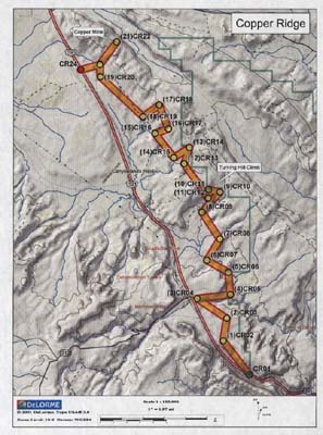
Click HERE for a FULL-SIZE printable
map
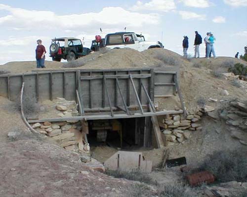
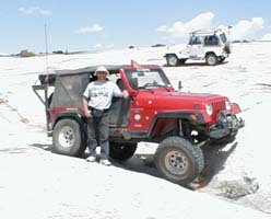
Here are a couple pictures from the Copper Ridge Trail.
On the left, slickrock is common across a significant portion of this
trail.
Webejeepin over a crevice to show off our flexibility.
On the right is an old, abandoned copper mine at the end of the
trail.
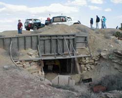
Click on picture for larger view, then "back" on
your browser to return here.
|
Waypoint: |
To: |
Distance |
Cumm. Dist. |
Bearing |
Lat |
Long |
|
CR01 |
|
|
|
|
N38° 37.089’ |
W109° 38.135’ |
| |
CR02 |
1.99 mi |
1.99 mi |
322° (NW) |
N38° 38.459’ |
W109° 39.490’ |
| |
CR03 |
1.08 mi |
3.07 mi |
9° (N) |
N38° 39.386’ |
W109° 39.306' |
| |
CR04 |
1.66 mi |
4.73 mi |
304°NW () |
N38° 40.189’ |
W109° 40.836' |
| |
CR05 |
1.55 mi |
6.29 mi |
83° (E) |
N38° 40.354’ |
W109° 39.121' |
| |
CR06 |
1.05 mi |
7.33 mi |
355° (N) |
N38° 41.260’ |
W109° 39.226' |
| |
CR07 |
1.15 mi |
8.48 mi |
300° (WNW) |
N38° 41.754’ |
W109° 40.334' |
| |
CR08 |
1.16 mi |
9.64 mi |
31° (NNE) |
N38° 42.620’ |
W109° 39.675' |
| |
CR09 |
1.51 mi |
11.15 mi |
327° (NNW) |
N38° 43.711’ |
W109° 40.596' |
| |
CR10 |
1.26 mi |
12.41 mi |
41° (NE) |
N38° 44.535’ |
W109° 39.672' |
| |
CR11 |
0.54 mi |
12.94 mi |
283° (WNW) |
N38° 44.638’ |
W109° 40.253' |
| |
CR12 |
0.40 mi |
13.35 mi |
183° (S) |
N38° 44.288’ |
W109° 40.279' |
| |
CR13 |
1.96 mi |
15.31 mi |
325° (NW) |
N38° 45.689’ |
W109° 41.520' |
| |
CR14 |
0.80 mi |
16.10 mi |
17° (NNE) |
N38° 46.348’ |
W109° 41.256' |
| |
CR15 |
0.87 mi |
16.97 mi |
237° (WSW) |
N38° 45.936’ |
W109° 42.065' |
| |
CR16 |
1.44 mi |
18.41 mi |
322° (NW) |
N38° 46.925’ |
W109° 43.044' |
| |
CR17 |
0.65 mi |
19.06 mi |
71° (ENE) |
N38° 47.110’ |
W109° 42.356' |
| |
CR18 |
1.19 mi |
20.26 mi |
339° (NNW) |
N38° 48.078’ |
W109° 42.832' |
| |
CR19 |
0.94 mi |
21.19 mi |
234° (SW) |
N38° 47.605’ |
W109° 43.678' |
| |
CR20 |
2.74 mi |
23.93 mi |
313° (NW) |
N38° 49.232’ |
W109° 45.899' |
| |
CR21 |
0.59 mi |
24.52 mi |
358° (N) |
N38° 49.747’ |
W109° 45.925' |
| |
CR22 |
1.30 mi |
25.83 mi |
37° (NE) |
N38° 50.653’ |
W109° 45.053' |
| |
CR23 |
1.32 mi |
27.15 mi |
216° (SW) |
N38° 49.726’ |
W109° 45.925' |
| |
CR24 |
0.92 mi |
28.07 mi |
255° (WSW) |
N38° 49.520’ |
W109° 46.915' |
Notice:
Off-highway travel is by its very nature potentially dangerous and could result
in property damage, injury, or even death. If you drive any of the trails
on this web site, you acknowledge these risks and assume full responsibility.
You are the final judge as to whether a trail is safe to drive, whether your
vehicle is capable of the journey, and whether your skills are up to the
challenge. The publisher of this web site disclaims any and all liability
for property damage, bodily injury, or death that could occur to you or any of
your passengers. To the best of my knowledge, the information
contained on this page was accurate as of the time I road this trail during the
Spring of 2001. However, things change over time. And portions
of this trail may no longer be legally accessible to motorized vehicles.
Therefore, please be good stewards of our sport--always stay on designated
trails . . . and always, always remember to
Tread Lightly!
Back
to the Utah Trails Page